Saturday, July 2, 2011

June Storm Pictures

Right now, it feels like the St. Louis summer has been one of these three on any given day:

1. Oppressively hot

2. Actually pretty nice

3. Stormy


Most of our storms have been either airmass (quick little pop ups) or linear systems that go by really quickly. However, we have had a few that decided to stick around for a bit, and on those storms, I was able to get some pretty nice pictures and video. These all happened at the end of the month. I hope you enjoy these!


Let's start off with Tuesday, June 21. Nothing too bad, just some really photogenic storms. There was a pretty nice lightning show with these storms, but it was mostly cloud to cloud. These storms came rolling in just at sunset, so I wasn't able to get the sharpest image. Still, I had to go for these shots!


Oh Mamma! Mammatus clouds to the south.


Same storm, just zoomed out a bit.


Next up is Saturday, June 25. A long line of storms set up across the area. There were some reports of high wind and 1" hail, but what really made this system impressive was all the lightning.


Sooooooo close to getting the most evasive shot in the weather world. I couldn't tell you if this was the beginning or end of the shot, but I had my camera aimed at the right place, and almost at the right time.


This lightning was impressive. Here is what our neighborhood looked like when lightning wasn't flashing.


Here's a shot of what the neighborhood liked while lightning was flashing. Looks like the middle of the day, but this shot was at 11:48 pm.


And of course, what would a lightning show be without some video? This video was shot just before I started taking pictures. I was indoors while shooting this. I was waiting for the lightning to be far enough away before I even thought of venturing outdoors for some photography. Earlier in the evening, we heard something get struck. Shortly after this video, something else nearby sounded like it got struck. After some time, I decided it was far enough away to go outside for photography. All that being said, enjoy the video.


Well, that's all I have for you this time. Hopefully, we'll get some more storms that decide they want to cooperate with the camera. Hope you enjoyed the pictures and video!

Tuesday, April 19, 2011

April Tunderstorm Pictures

April has been a great month so far. Namely, because we have had some cool thunderstorms. To make things interesting, there are still tornado warnings around the area, but since I'm out of them, I'll post up some pics of what I saw from home.


I'll start with the "big" day so far. April 19, 2011. You know it's going to an interesting day when storm chasers swarmed St. Louis...


Towers off to the Northeast.


Same towers with different lighting, as a storm rolled in.


Turbulent clouds.


More dark clouds. Intimidating, but that is about it.


Another cool looking cloud, but that's all it is.


There was some cool cloud movement with this video clip, but I realized my camera didn't do it justice, even after I zoomed in on it. Some of you may still enjoy it, though!


Hail to the hail!


Sorry it was blurry, but I didn't have great lighting. If I used the flash, the image was just a white shape. That is a nickel and a quarter. We actually ended up with some dime sized hail, which is the largest size hail I have actually witnessed falling.


These were from a few days ago (April 15), but it was a few cool cloud and hail shots!


Nice turbulent look in the clouds.


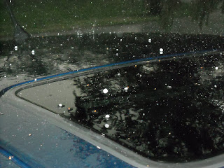
Pea sized hail bouncing off the top of my car.


I hope you enjoyed the pictures. I know I sure enjoyed taking them! As I'm posting all this, those storms (April 19) are still rolling on along, causing Tornado Warnings in southern Illinois. The storm system really looks nice, and it looks like it is finally reaching it's full strength! Here are the current SPC storm reports. They should update as the reports keep coming in.

Friday, March 11, 2011

Man vs. Machine, Day 5, Final Day

Well, this is the last forecast in this Man vs. Machine forecast contest. Day 4 was a bust, but it is just a matter of waiting until the forecast period is over to get the actual high. Unofficially, I saw a temp of 58 today, so even though I busted the temp, I'm not complaining. That being said, let's finish this contest off, and I'll try to end it on a good one. The forecast period is 7:00pm CST March 11-7:00pm CST March 12.

As always, let's start out at 500 mb. The large trough is now negatively tilted, and it is mostly impacting New England and then moving out of the United States. Behind that, we have a ridge, and the ridge will be right on top of our location before too much longer. This is typically a sign of nicer weather and warmer temperatures.

At 850 mb, things had to change at the last minute. Since the upper air soundings are taken at 7 am and 7 pm, there is a lot that can happen in the day. That is the main reason I busted temps yesterday. The 7 am map had weak cold air advection over the area, and the 7 pm map had warm air advection. That seriously impacted my temp forecast. At 850 mb now (which is off the 7 am map), the warm air advection continues. This will factor into the possibility of warmer temperatures.

The surface map is active. We have the low that impacted the area still in the United States, over New England. Then there is a low over Minnesota. This low has a cold front that may impact our area late tomorrow night or on Sunday morning. This front will more than likely pass after the forecast period is over. Finally, behind that low, there is yet another low off the Pacific Northwest. The main feature helping our weather is an area of high pressure in Louisiana. Out of all the high pressure areas on the map, this one is the highest at 1026 mb.

On the visible satellite, there were a few clouds over the area, but nothing like the past few days. At most, we were at partly cloudy today, so not too bad at all. The radar is also showing nothing, because no clouds means no precipitation. However, there is an area of clouds out in central Missouri that will probably move in ahead of the front. Looks like we'll see clouds again tomorrow.

Alright, rolling out the temperature correction chart once again for temperature forecasting. This time with warm air advection instead of cold air advection. The clouds are gone, but the winds are still pretty strong. With the nice pressure gradient over us, I don't think that is going to change at all. We've got a dew point around 30, but with warm air advection at 850 mb, I don't think the low will bottom out tonight. I'm forecasting a low of 37 degrees. Tomorrow, we should have some clouds starting to move in, so that may impact temperatures a little bit. 850 mb warm air advection should help keep the temp a bit warmer. With all this in mind, I'm forecasting tomorrow's high to be 62. I really hope this one verifies, and not just to beat the machines. It really would be nice to have temps in the 60s. With clouds moving in, we'll have partly cloudy skies, and no precipitation is expected.

Here goes nothing. Final day of contest forecasts:

Man vs. Machine Day 5 Forecasts:

Man:
Low: 37
High: 62
Weather: Partly Cloudy
Precip: 0.00"

GFS:
Low: 39
High: 58
Weather: Cloudy tonight, clear tomorrow
Precip: 0.00"

NAM:
Low: 39
High: 57
Weather: Partly Cloudy with increasing clouds
Precip: 0.00"

Well, this is it. One last wait to see which will verify. I'll put verification in the comments below. For those who stuck out reading the forecasts, thank you very much. And although I should be as neutral as possible, let's go human forecasting!

Thursday, March 10, 2011

Man vs. Machine, Day 4

So far the day 3 forecast is shaping up beautifully. Everything is almost spot on. There have been some stronger than expected winds, but that hasn't affected the forecast by that much at all. That being said, let's move on to day 4 of the contest. Once again, the forecast is for Alton, IL , with the forecast period being 7:00pm CST March 10-7:00pm CST March 11.

The 500 mb jet stream is still showing a strong trough, but it is over the Ohio Valley. Illinois is now west of the trough axis, and the ridge is on the way. Time for a little weather lesson. Once again, the actual event is more complicated. In order to get the general point across of why this is important, it will be simplified. Our location is next to a jet streak (which is a speed increase in the jet stream). We are located on the left entrance region, which is where one expects to find convergence. An area of convergence in the upper atmosphere helps push air down, while an area of divergence helps lift air up. (It all deals with vorticity or spin.) So what does this all mean for the weather forecast? Really simply, it means is air is being "pushed" down from the upper atmosphere, which helps create an area of higher surface pressure. With high pressure, you generally get nicer weather. For our area, the upper atmospheric forcing will be a big contributor in having nicer weather.

At 850 mb, there really isn't anything that should affect our area too much. There is a bit of cold air advection, which might impact temperatures, but that is about it. It's not strong, but it is there.

On the surface map, the low we just had is pushing out of the United States. Most of the continental United States is under an area of high pressure. The only other low pressure I have on my map is in British Columbia.

The last satellite images I looked at were promising for our area. The clouds were pushing out, and it looks like they will be gone within a few hours. We'll be able to see the sun tomorrow, which is a nice break from all the cloudiness as of late. Also, nothing on the radar. There was a little bit of drizzle last night around midnight, but no accumulation occurred.

With not too much to discuss, it is time to put this forecast together. No clouds tonight means we lose our "blanket" over the area. This means temps can fall tonight. I'm forecasting the low to be at 33 degrees. Tomorrow we will actually see the sun, and that means we can warm up the surface a bit. Provided the winds don't kick up too high, I will forecast my high to be at 48 degrees, through the use of a temperature correction chart. I'm not sure if we'll get a big warm up, but temps should start to rise.

Man vs. Machine Day 4 forecasts:

Man:
Low: 33
High: 48
Weather: Clear skies
Precip: 0.00"

GFS:
Low: 27
High: 51
Weather: Clear skies
Precip: 0.00"

NAM:
Low: 28
High: 53
Weather: Mostly Sunny (it calls for clear skies and partly cloudy skies, leaning more towards clear)
Precip: 0.00"

Another NWS Comparison:
Low: 28
High: 61
Weather: Sunny

Well, every forecast agrees on precip, but the high and low remains to be seen. Major gap between myself at 48 and the NWS at 61. The models are putting it right around 52. I just think the cold air advection at 850 mb will keep temps cooler. Like always, time will tell who is closer. Find out tomorrow!

Wednesday, March 9, 2011

Man vs. Machine, Day 3

Well, so far the day 2 forecast is still up for grabs. The high today was reached this morning, and the air temperature has been falling all day. It is time to start the day 3 forecast. This will cover between 7:00pm CST March 9-7:00pm CST March 10 for Alton, IL.

The 500 mb trough has pushed eastward, and as of 7:00 am CST, we were located near the trough axis (middle of the trough). Behind this trough is a ridge, which will bring nicer weather with it. Next, I took a look at the 850 mb layer. The southerly flow we had earlier this week (yes, even yesterday) has been cut off by westerly flow. The southerly flow is now farther to the east. This will cut off our major source of moisture.

The surface map has a few noticeable changes. There is a strong high pressure system north of Maine and another one located north of the Four Corners. The low pressure system that was located in Texas yesterday is now located in Indiana. The cold front actually pushed through Alton earlier today. It actually started in the morning, and pushed out by early afternoon. The next low pressure system is sitting off the Pacific Northwest.

Visible satellite imagery from earlier today showed the cloud shield still sitting over Missouri and Illinois. This will move out with the surface low. There wasn't anything on the St. Louis radar imagery. There has been a very small amount of precipitation this afternoon, but I doubt it was anything measurable. The majority of our rain in the previous forecast period occurred last night.

With very little happening weather-wise (at least for our area), this discussion will be short and sweet. The cold front that pushed through today is going to lower our temperatures for tomorrow. Unfortunately, it should be colder tomorrow than today. I'm forecasting the low to reach 37 tonight. Tomorrow, there will still be cloud cover, and I'm not sure that we'll get all that warm. Temperatures behind this front have all been in the 30s. We should be warmer than that, but not by too much. I'm forecasting tomorrow's high to be in the low 40's, with 41 being my forecast high. It should be mostly cloudy with cloud coverage breaking up throughout the day. We might see partly cloudy skies by tomorrow night. I'm not expecting any precipitation for tomorrow.

Man vs. Machine Day 3 Forecasts:

Man:
Low: 37
High: 41
Weather: Mostly Cloudy, with clouds breaking up throughout the day
Precip: 0.00"

GFS:
Low: 34
High: 45
Weather: Overcast skies, with a 30% chance of precip
Precip: 0.00"
NAM:
Low: 33
High: 44
Weather: Overcast skies, with a 43% chance of precip
Precip: .01-.09" of rain

Once again, time will tell how this chapter in the contest turns out. Tomorrow's forecast discussion will probably come out later than usual (probably the same time as today). I've got to go to class, and then I'll have to analyze the maps, so I may not get the discussion out as quickly. It should be up before 7:00pm CST. That's all for now. Thanks for reading!

Tuesday, March 8, 2011

Man vs. Machine, Day 2

So far, yesterday's forecast is looking pretty good. I find it odd, that when I last did the forecast contest, it was raining. I do it this time, and it rains again. Anyway, I'll give the verification information shortly after 7:00pm CST, after the data is reported. I may have to do a site close to Alton for precipitation verification, though. Alton/St. Louis Regional Airport is not reporting any precipitation, and I know for a fact it has been raining since before noon. It has mostly been light rain, but still there should be some measurable amount by now. All that aside, it is time for the next forecast. This forecast period is between 7:00 pm CST March 8-7:00 PM CST March 9.

What a difference a day can make in the jet stream. Yesterday there weren't any real noticeable troughs or ridges at 500 mb, just shortwave troughs. Today's 500 mb analysis provides a completely different story. There is a fairly large trough sitting across the central United States. The data from 7:00 am CST, places the edge of the trough near the Kansas/Missouri border. Behind the trough is a ridge over California.

The 850 mb map still shows strong southerly flow off the Gulf of Mexico. This will continue to provide a nice moisture inflow for the forecast area. There is also warm air advection at the 850 mb level. All this combined with the current cloud cover should help keep the nighttime low at or above last night's low. (Which was 40). This will probably aid in keeping rain around tomorrow, although it should mostly be light rain, probably nothing heavier than showers.

As for the surface map, there still isn't too much happening. The low from yesterday actually moved slightly through Texas. At the synoptic scale view, it appears to have a stationary front, a dryline, and a cold front. However, once I examined this system at the mesoscale level, I still felt it was necessary to place a warm front across Arkansas into Tennessee, rather than a stationary front. This front is giving some forcing to the system, which means it is helping to maintain the rain.

Visible satellite is showing what looks like convective towers out in western Missouri into Kansas. Radar imagery out of the Kansas City NWS also shows storms. However, they are pushing north, and should not affect our area at all. Other than that, there is just a large cloud shield on satellite, and radar imagery out of the St. Louis NWS shows a large area of precipitation with some areas being slightly stronger than others. A look at the national view of the visible satellite imagery shows the large cloud shield over the central United States. Based on this loop, I feel confident in saying that there will still be cloud cover tomorrow, but it may push out late Wednesday night into the morning on Thursday.

Now it is time to put it all together. I put a large amount of values into a temperature correction table, which helps me forecast temperatures based on current and predicted weather conditions. This takes into account many factors, such as cloud cover, precip, wind, and more. These values either add or subtract a value to the temperature, and it is a pretty accurate way to forecast temperature. That being said, after working the numbers on the chart and factoring in the dew point, I am forecasting tonight's low to be at 39 degrees, and I am forecasting tomorrow's high to be at 51 degrees. It looks like we will still have showers and light rain, but I think we should have a relatively low amount, probably somewhere between .15-.25" of rain.

The Wednesday Forecasts:

Man:
Low: 39
High: 51
Weather: Showers and light rain
Precip: .15-.25" of rain

GFS:
Low: 45
High: 50
Weather: 100% chance of precip
Precip: .5-.99" of rain

NAM:
Low: 43
High: 45
Weather: 90% chance of precip
Precip: .25-.49" of rain


Time will tell as the forecast contest keeps on going. Forecast verification will be placed in the comments section of this post. Just like yesterday, I hand analyzed my own maps, using the same site for the raw data. I might post them after the contest, just because it takes a while to do them indiviually. That's all for now. At least, until the next forecast!

Monday, March 7, 2011

Man vs. Machine Week, Day 1

It's time to start the Man vs. Machine weather forecast challenge for this week. This is the first day of the forecast challenge. Just some quick reminders, the forecast is for Alton, IL. Also, I am not allowed to use models or model produced data. After I make my forecast, the model forecasts will be displayed, with numerical values coming from the model's MOS (Model Output Statistics) data. The competition is between:
1. The GFS (The Global Forecast System)
2. The NAM (The North American Mesoscale [model])
3. Me

Alright, here it goes. Starting off at the 500 mb jet stream, there isn't too much going on. There aren't any real big troughs or ridges, but there are a few shortwaves troughs over Kansas and Colorado. These will probably help kick up some weather sometime tomorrow afternoon, as they approach the area. The next layer I want to look at is the 850 mb layer. What I find of importance here is the southerly flow off the Gulf of Mexico. It is strong over eastern Texas and across Louisiana, but as it hits the Ozarks, the winds take a turn to the east. That should provide some moisture tonight and tomorrow. Combined with the 500 mb shortwave troughs, that could provide chances of rain tomorrow. The shortwaves help with forcing or lift, and 850 flow gives moisture, so moisture and lift should be present tomorrow.

The next area I want to look at is the surface map. Really not too happening on the surface map either. There is a system in New England, but it is moving out of the US. Then there is a strong high pressure located around James Bay in eastern Ontario. There is a low located over the Rocky Mountains, but the low I am most interested in is located just south of the Oklahoma panhandle. With this low, I noticed what seems to be a weak warm front. There is a slight wind change, and a slight temperature gradient. It's nothing that jumps off the map, but I feel this was strong enough to place a front there. The only other noticeable feature with this system is the dryline down western Texas back into Mexico.

The visible satellite imagery shows a fairly large area of cloud cover over the central United States. There is a little bit of a break over eastern Missouri, which means Alton may get a little bit of sunshine later on today. The next area of cloud break is back in central Kansas. The radar shows very little going on. It looks mostly like a few light showers over central Missouri, and maybe some really light showers in central Illinois.

Now is when everything starts to roll all together. We've got moisture coming in from the Gulf of Mexico. There are some shortwave troughs at 500 mb, which should help with forcing. The low in Texas should push northeasterly, which would put Alton north of the warm front tomorrow. I don't really see the cloud cover breaking up anytime soon. I would say there is a chance of rain and thunderstorms tomorrow afternoon. There isn't strong moisture here, but it should be enough for showers with some storms, so I'll put my rain amount around .5 inch. (Give or take .05 inches).

Now the real challenge, the temperatures. For the high, I am going to look at the surface map for some guidance. The temps are mostly in the upper 40s north of that warm front. With the cloud cover, you're not going to get the sun to warm up the surface like it would on a clear day. The current temp in Alton is 41. It is mostly cloudy with a bit of sun breaking through. The clouds overnight will help maintain a warmer temp. Tomorrow's high should be in the upper 40s. I'll go with a high of 49. As for tonight's low, it can't fall below the dew point, so that helps establish a lower limit. The current dew point is 34. With some moisture advecting in, that should raise the dew point a little. With current dew points south of here not being too much higher, I'll put tonight's low at 37. Since the new day in Zulu time is at 7 pm, that is when I will grab the data for verification. The next forecast period will start at 7pm CST March 8 and go to 7pm CST March 9.

So Man forecast:
Tonight's low: 37
Tomorrow's high: 49
Conditions: Showers and thunderstorms
Precip: around .5 inch (+/- .05")

GFS:
Low: 34
High: 57
Weather: 70% chance of rain
Precip: .1-.25" of rain

NAM:
Low: 35
High: 55
Weather: 80% chance of rain
Precip: .1-.25" of rain

And just for comparing the NWS in St. Louis Point forecast:
Low: 36
High: 55
Weather: 60% showers with 90% storms Tuesday night
Precip: Not listed.

By the way, I linked up the maps I normally do after the discussion, if you want to see what type of data I used here are the links. [Surface US and Local ] [500 mb] [850 mb]I made a mistake of trying to analyze the maps in Microsoft Paint, which works, but makes them harder to read. Tyring to save on some paper. I'll post the forecast verification in the comments section after the forecast period is over, and I'll have a new discussion up tomorrow.