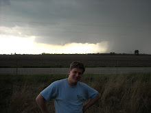

As we got south of Springfield, we noticed another wall cloud. We pulled off the side of the road to watch this one for a little while. This one actually was rotating. It was really cool to watch the clouds form right off the tip of the rain foot. Neither of these wall clouds produced a tornado, but they were cool to watch!

This is another view of the Springfield wall cloud. You can see the rain foot wrapping around the backside of the wall cloud in this picture.
Here is a video of the rotating wall cloud. It is a bit difficult to see on the video, but it was rotating very nicely. (We also had a lot more time to watch it, so it was easier to see it rotate.)
Here are some pictures of this impressive storm we were under. These were taken outside of Litchfield, IL looking north:

Later that night, a storm rolled through Alton, IL. There was actually a wind damage report, as one of the older buildings had a roof blown off. (SPC Reports). I was able to see some hail from my house and catch some lightning shots.
I like how you can see the hail falling in this picture. I wasn't even trying to get this picture of hail falling, but I caught it and am quite happy with it.
Just an idea of how much hail fell. Mostly pea-sized, but we had a few that were around 3/8 inch.
I tried to get some lightning, but it is hard to photograph. I did end up with some interesting lightning shots:


Well, that's all for this time. Hope you enjoyed it as much as I did!


Good stuff Chuck! I didn't make it out on that day, but I posted some lightning photos from last night on my blog as well. Not liking the pattern overall though for the plains in the next week.
ReplyDeleteThanks, Chuck! Beautiful photos! I love seeing stuff like this, and your explanations make it much more interesting!
ReplyDelete