April has been a great month so far. Namely, because we have had some cool thunderstorms. To make things interesting, there are still tornado warnings around the area, but since I'm out of them, I'll post up some pics of what I saw from home.
I'll start with the "big" day so far. April 19, 2011. You know it's going to an interesting day when storm chasers swarmed St. Louis...
Towers off to the Northeast.
Same towers with different lighting, as a storm rolled in.
Turbulent clouds.
More dark clouds. Intimidating, but that is about it.
Another cool looking cloud, but that's all it is.
There was some cool cloud movement with this video clip, but I realized my camera didn't do it justice, even after I zoomed in on it. Some of you may still enjoy it, though!

Hail to the hail!

Sorry it was blurry, but I didn't have great lighting. If I used the flash, the image was just a white shape. That is a nickel and a quarter. We actually ended up with some dime sized hail, which is the largest size hail I have actually witnessed falling.
These were from a few days ago (April 15), but it was a few cool cloud and hail shots!

Nice turbulent look in the clouds.
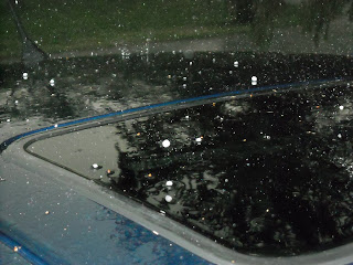
Pea sized hail bouncing off the top of my car.
I hope you enjoyed the pictures. I know I sure enjoyed taking them! As I'm posting all this, those storms (April 19) are still rolling on along, causing Tornado Warnings in southern Illinois. The storm system really looks nice, and it looks like it is finally reaching it's full strength! Here are the current SPC storm reports. They should update as the reports keep coming in.


